Publicly accessible, high-quality satellite imagery has been a game changer in terms of understanding the scope of forces such as urbanization and land use patterns.
Google Timelapse Maps
Google Earth’s timelapsed satellite maps capture the drastic changes the planet’s surface has undergone over the past 34 years. Each timelapse comprises 35 cloud-free pictures, which have been made interactive by the CREATE Lab at Carnegie Mellon University. Three different satellites acquired 15 million images over the past three decades. The majority of the images come from Landsat, a joint USGS/NASA Earth observation program. For the years 2015 to 2018, Google combined imagery from Landsat 8 and Sentinel-2A. Sentinel is part of the European Commission and European Space Agency’s Copernicus Earth observation program. Deforestation, urban growth, and natural resource extraction are just some of the human patterns and impacts that can be visualized. Editor’s note: to view the following timelapses, press the play button on any map. You can also view individual years in the time periods as well. On slower internet connections you may need to have patience, as the series of images can take some time to load or display.
Cities and Infrastructure
Urban Growth: Pearl River Delta, China
Up to 1979, China’s Pearl River Delta had seen little urbanization. However in 1980, the People’s Republic of China established a special economic zone, Shenzhen, to attract foreign investment. In the following years, buildings and paved surfaces rapidly replaced the rural settings around the river delta. This is the Lunjiao area just south of Guangzhou.
Urban Growth: Cairo, Egypt
The present-day location of Cairo has been a city for more than 1,000 years, and its constrained urban footprint is now bursting at the seams thanks to Egypt’s population growth. A new city is being built in the nearby stretch of desert land (agricultural land is scarce) that will one day replace ancient Cairo as Egypt’s capital. If the government’s ambitious plans are realized, this desert boomtown could have a population of over 6 million people.
– Khaled el-Husseiny Soliman
Urban Growth: Phoenix, Arizona
According to estimates from the U.S. Census Bureau, Phoenix is the fastest-growing city in the United States. Over the past two decades, the suburb of Chandler evolved from agricultural uses to sprawling residential developments. This pattern was repeated in a number of cities in the Southern U.S., most notably Las Vegas.
Construction: The Brandenburg Airport, Germany
Berlin’s long overdue Brandenburg Airport began construction in 2006, with the airport initially expected to open in 2011. However, the airport has been subject to numerous delays and the airport now has a new opening date. Berlin Brandenburg Airport is now expected to open on Oct. 31, 2020.
Megaproject: Yangshan Port
The Port of Shanghai became one of the most important transportation hubs in the world after the completion of its offshore expansion – the Yangshan Port. Building this massive port was a gargantuan engineering feat. First, land reclamation was used to connect two islands 20 miles southeast of Shanghai. Next, the port was connected to the mainland via the Donghai Bridge, which opened in 2005 as the world’s longest sea crossing. The six-lane bridge took 6,000 workers two and half years to construct. In 2016, the Port of Shanghai was the largest shipping port in the world, handling 37.1 million twenty-foot container equivalents.
Resource Extraction
Mining: Chuquicamata, Chile
Chuquicamata is the largest open pit copper mine by volume in the world, located 800 miles north of the Chilean capital, Santiago. In 2019, Chile’s national mining company Codelco initiated underground mining at Chuquicamata.
Deforestation: Ñuflo de Chávez, Bolivia
Shale Gas Boom: Odessa, Texas
The small town of Odessa sits in the middle of one of the most productive shale gas regions in the world, the Permian Basin. The region is expected to generate an average of 3.9 million barrels per day, roughly a third of total U.S. oil production. While the gas may come from underground, the pursuit of this source of energy has drastically altered the landscape, marking the terrain with roads, wells, and housing for workers.
Changing Environment
Drying of the Aral Sea: Kazakhstan and Uzbekistan
It took almost 30 years to make a sea disappear. When the Soviet Union diverted the Amu Darya and Syr Darya rivers to irrigate cotton and rice fields in the 1960s, it turned the Aral Sea into a desert. Once the world’s fourth largest lake, the region is struggling to restore water levels and aquatic habitats.
Glacier Retreat: Columbia Glacier, Alaska, USA
The Columbia Glacier is a tidewater glacier that flows through the valleys of the Chugach Mountains and into Alaska’s Prince William Sound. Increased temperatures initiated a retreat in the length of the glacier over three decades ago. Once in motion, a glacier’s retreat accelerates due to glacial mechanics. It is one of the most rapidly changing glaciers in the world.
Changing Rivers: Iquitos, Peru
Not all change is from humans. There are natural physical processes that continue to shape the Earth’s surface. For example, rivers that experience heavy water flows can be altered through erosion, changing the bends.
Better Perspectives, Better Decisions?
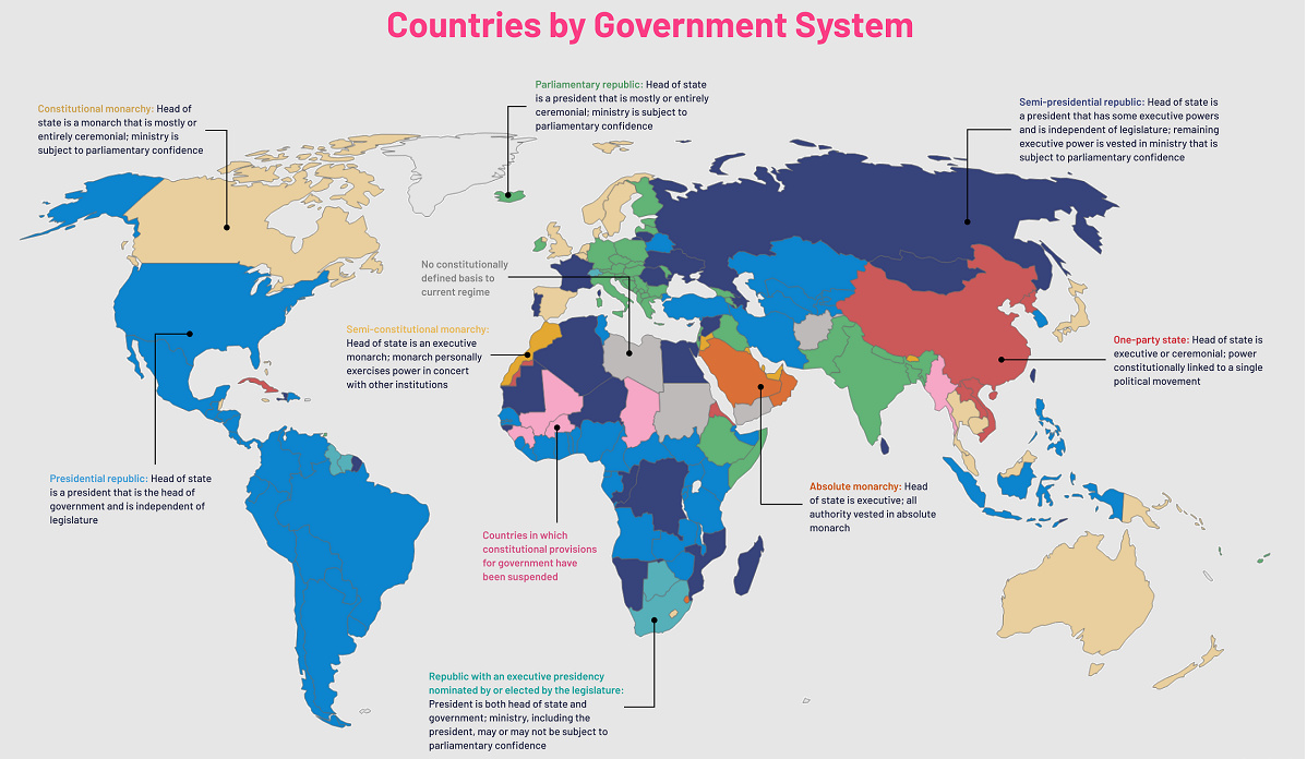
Often, the greatest impacts that occur are out of sight and mind. However, with the increasing availability of satellite technology and improved distribution of images through platforms such as Google Timelapse, the impact of human activity is impossible to ignore. The bulk of visible changes come from human economic activity, because it is more easily observable on a smaller time scale. However, it’s also worth remembering that there are still many natural processes that take generations, if not thousands of years to affect change. It is one thing to hear the facts and figures of humankind’s impact on the environment, but to see the change is a whole other story. on Even while political regimes across these countries have changed over time, they’ve largely followed a few different types of governance. Today, every country can ultimately be classified into just nine broad forms of government systems. This map by Truman Du uses information from Wikipedia to map the government systems that rule the world today.
Countries By Type of Government
It’s important to note that this map charts government systems according to each country’s legal framework. Many countries have constitutions stating their de jure or legally recognized system of government, but their de facto or realized form of governance may be quite different. Here is a list of the stated government system of UN member states and observers as of January 2023: Let’s take a closer look at some of these systems.
Monarchies
Brought back into the spotlight after the death of Queen Elizabeth II of England in September 2022, this form of government has a single ruler. They carry titles from king and queen to sultan or emperor, and their government systems can be further divided into three modern types: constitutional, semi-constitutional, and absolute. A constitutional monarchy sees the monarch act as head of state within the parameters of a constitution, giving them little to no real power. For example, King Charles III is the head of 15 Commonwealth nations including Canada and Australia. However, each has their own head of government. On the other hand, a semi-constitutional monarchy lets the monarch or ruling royal family retain substantial political powers, as is the case in Jordan and Morocco. However, their monarchs still rule the country according to a democratic constitution and in concert with other institutions. Finally, an absolute monarchy is most like the monarchies of old, where the ruler has full power over governance, with modern examples including Saudi Arabia and Vatican City.
Republics
Unlike monarchies, the people hold the power in a republic government system, directly electing representatives to form government. Again, there are multiple types of modern republic governments: presidential, semi-presidential, and parliamentary. The presidential republic could be considered a direct progression from monarchies. This system has a strong and independent chief executive with extensive powers when it comes to domestic affairs and foreign policy. An example of this is the United States, where the President is both the head of state and the head of government. In a semi-presidential republic, the president is the head of state and has some executive powers that are independent of the legislature. However, the prime minister (or chancellor or equivalent title) is the head of government, responsible to the legislature along with the cabinet. Russia is a classic example of this type of government. The last type of republic system is parliamentary. In this system, the president is a figurehead, while the head of government holds real power and is validated by and accountable to the parliament. This type of system can be seen in Germany, Italy, and India and is akin to constitutional monarchies. It’s also important to point out that some parliamentary republic systems operate slightly differently. For example in South Africa, the president is both the head of state and government, but is elected directly by the legislature. This leaves them (and their ministries) potentially subject to parliamentary confidence.
One-Party State
Many of the systems above involve multiple political parties vying to rule and govern their respective countries. In a one-party state, also called a single-party state or single-party system, only one political party has the right to form government. All other political parties are either outlawed or only allowed limited participation in elections. In this system, a country’s head of state and head of government can be executive or ceremonial but political power is constitutionally linked to a single political movement. China is the most well-known example of this government system, with the General Secretary of the Communist Party of China ruling as the de facto leader since 1989.
Provisional
The final form of government is a provisional government formed as an interim or transitional government. In this system, an emergency governmental body is created to manage political transitions after the collapse of a government, or when a new state is formed. Often these evolve into fully constitutionalized systems, but sometimes they hold power for longer than expected. Some examples of countries that are considered provisional include Libya, Burkina Faso, and Chad.